Lake Lanao description and photos - Philippines: Mindanao Island
Rating: 8,1/10 (1033 votes) 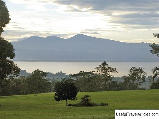
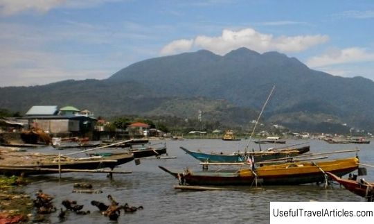
Lake Lanao description and photos - Philippines: Mindanao Island. Detailed information about the attraction. Description, photographs and a map showing the nearest significant objects. The name in English is Lake Lanao. Photo and DescriptionLanao, also known as Ranau, is the largest lake on the island of Mindanao, located in the South Lanao province. The total area of the lake is 340 square kilometers, length - 33 km, width - 20 km. The maximum depth of the lake is 112 meters, the average is 60.3 meters. Lanao is considered one of the 15 oldest lakes in the world. Another feature is its location at an altitude of 700 m above sea level. Rice growing is widespread on the low and flat shores of Lanao. 4 rivers flow into the lake, and only one flows out - Agus, which then flows into the Iligan Bay. The river is notable for the most beautiful waterfalls of Maria Cristina, which are sometimes called "twin falls". A hydroelectric power plant was also built here, which provides up to 70% of the electricity needs of the inhabitants of Mindanao. Lanao is the object of many myths and legends of the local tribe "Maranao" - the very name of this tribe means "people living on the shores of the lake." In the myths, the origin of the lake is described in this way: once upon a time, angels under the leadership of the Archangel Gabriel moved the inhabitants of one city to another place so that the world would not turn over from overpopulation. However, the resulting void was soon filled with water, which nearly flooded the rest of the world. To prevent the catastrophe, the angels called for help from the four elements, so that they made a hole, and the water flowed out - this is how Lake Lanao and the Agus River were formed. In 1992, the lake was declared a catchment reserve, which means that the vegetation on its shores and water runoff are under special protection to provide water for hydroelectric power plants, irrigation systems and agriculture. The area of the reserve is 153 thousand hectares. On its territory, you can find a wide variety of flora and fauna, including several species of cyprinids, which are endemic to the lake. Back in the early 1980s, scientists were concerned that these species were on the verge of extinction due to the negative impact of hydroelectric power plants and the introduction of alien species. So, due to the appearance of white gobies in the waters of the lake, the population of cyprinids has significantly decreased - only 5 of 18 species remain today.       We also recommend reading Catedral de Trujillo description and photos - Peru: Trujillo Topic: Lake Lanao description and photos - Philippines: Mindanao Island. |