Geographical center of Europe description and photo - Lithuania
Rating: 8,4/10 (242 votes) 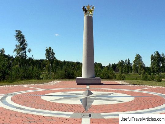
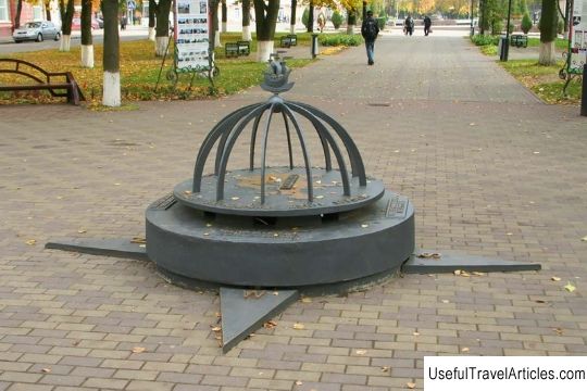
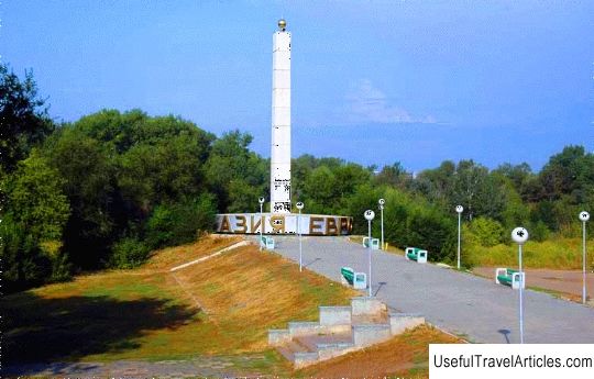
Geographical center of Europe description and photo - Lithuania. Detailed information about the attraction. Description, photographs and a map showing the nearest significant objects. Title in English - Geographical center of Europe. Photo and DescriptionThe Geographical Center of Europe is a hypothetical point that points to the geographic center of Europe. The location of this center depends on the definition of the European borders as well as on the chosen counting method. In addition, the presence of the inclusion of remote islands in the list of the most extreme points of European territory also affects. It is for these reasons that places claim the title of a European geographical center: a point near the village of Delovoe, a point south-west of Polotsk, the village of Purnushkiai near Vilnius, Suhovolya (northeastern part of Poland), a point in central Slovakia - the village of Kragule. The first attempt to determine the geographic center was made in 1775 by Shimon Anthony Sobekraisky - cartographer and astrologer Augustus Poniatowski - king of the Polish-Lithuanian Commonwealth. Then it was decided that the central point is located in the city of Sukhovol, namely on the market square in the western part of the Lithuanian principality. In 1885-1887, geographers from the Austro-Hungarian Empire decided to conduct a geodetic survey of the region in Transcarpathia for in order to determine the place of construction of the railway. Research has shown that the center of Europe can be located in the Upper Tissen Basin. In the 1900s, the German Empire began to make its own calculations. Geographers found that the Austrian measurements were wrong. German researchers believed that the European center was located in the city of Dresden, the capital of Saxony, not far from the Frauenkirche church. After the end of the Second World War, Soviet scientists established that the version of the Austrians was correct and then the sign located in Rakhiv was redone. On May 27, 1977, a 7.2 meter high stele was built next to the old sign. In 1989, the French scientists of the National Institute of Geography identified the location of the European geographic center. It turned out to be a point not far from Vilnius (26 km to the north) in the village of Purnushkiai. In their work, scientists used the scientific method of centers of gravity. After the location of the center was found, the question arose about its designation. The very first mark of the European Geographic Center was installed in 1991, which was a masonry with a slab. The point was located on a hill near Bernotay. But this monument has not survived to us. Only later, thanks to the works of the Society of Lithuanian Geographers, in the area of the center, a 9-ton stone found in the nearby fields found its place. Geographers attached a metal panel with the appropriate inscription. The following year, in order to preserve the environment of the European geographic center, the Lithuanian Supreme Council established a special cartographic reserve dedicated to the center of Europe. In the area where the reserve is located, there is Lake Giriyos, as well as Alkakalnis - the sacrificial mountain for the burial of pagans and the Bernotite hillfort. On one side, the reserve is surrounded by a forest. The Bernotes castle mound is considered one of the oldest in the whole of Lithuania. There is an assumption that a defensive fortress was located in its place as early as in the 1st-5th centuries. Here archaeologists have discovered clay and molded fragments of ceramics. Among the possible centers of Europe is Kragule, a Slovak city located near Kremnica. Now there is a ski resort in this place. There is a memorial stone on the site, which is considered to be the center, and there is also a hotel called "Center of Europe" in the city. In May 2004, the geographical center of Europe was opened. This event contributed to the accession of Lithuania to the European Union. The sculptural composition was created by the author Gediminas Jokubonis. It was a column made of white granite, at the top of which is a star crown. At the end of May 2008, another monument was erected in the city of Polotsk - a memorial sign. This information about the geographical center of Europe was found by Belarusian scientists, which was confirmed by Russian scientists. But despite this,   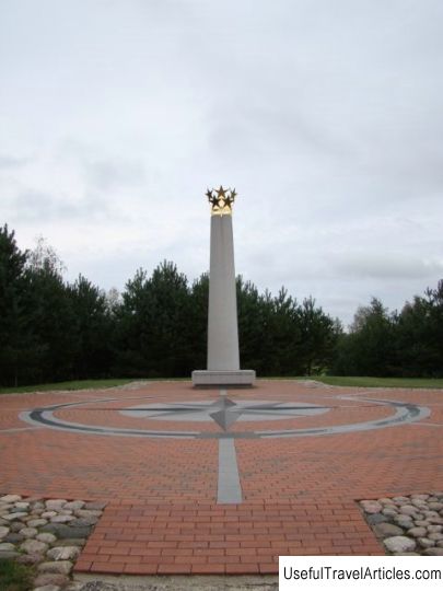 We also recommend reading Government House description and photos - Fiji: Suva Topic: Geographical center of Europe description and photo - Lithuania. |