Krakatoa volcano description and photos - Indonesia: Java Island
Rating: 7,6/10 (312 votes) 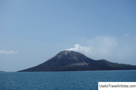
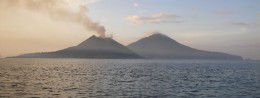
Krakatoa volcano description and photos - Indonesia: Java Island. Detailed information about the attraction. Description, photographs and a map showing the nearest significant objects. The name in English is Krakatoa. Photo and descriptionKrakatoa is a volcanic island located in the Sunda Strait between the islands of Java and Sumatra, in the Lampung province. It is worth noting the fact that this province is known for its volcanic instability - in May 2005, there was a strong earthquake (6.4 points), which caused great damage to Lampung province. One of the attractions of Lampung province is Tanjung Setia Beach, which is also famous for its unusual and challenging waves for surfers. Krakatoa is also called a group of islands that formed from a larger island (with three volcanic peaks), which was destroyed by the eruption of the Krakatoa volcano in 1883. The eruption of Krakatoa in 1883 triggered a giant tsunami people died (according to some sources - about 40,000 people), two-thirds of the island of Krakatoa was destroyed. It is believed that the sound from the eruption was the loudest ever recorded in history - it was heard 4800 km from the volcano, and the giant waves provoked by the eruption were recorded by barographs around the globe. Scientists calculated that the force of the explosion was 10 thousand times greater than the explosion that destroyed the city of Hiroshima. In 1927, a new island appeared, Anak Krakatoa, which means "child of Krakatoa". An underwater eruption took place at the site of the destroyed volcano, and a new volcano rose 9 meters above the sea in a few days. At first it was destroyed by the sea, but over time, when the lava flows poured out in greater quantities than the sea destroyed them, the volcano finally won its place. It happened in 1930. The height of the volcano changed every year, on average the volcano grew by about 7 meters per year. Today the height of Anak-Krakatau is about 813 meters. Due to the fact that Anak-Krakatoa is an active volcano, and its status is the second level of alarm (out of four), the Indonesian government has officially banned residents from settling closer than 3 km from the island, and a zone with a radius of 1.5 km from the crater is closed for tourists and fishing enthusiasts.    We also recommend reading The stone horse and the chapel of Arseny Konevsky description and photo - Russia - Leningrad region: Priozersky district Topic: Krakatoa volcano description and photos - Indonesia: Java Island. |