Dabas parks Daugavas loki description and photo - Latvia: Daugavpils
Rating: 8,0/10 (890 votes) 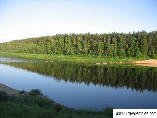
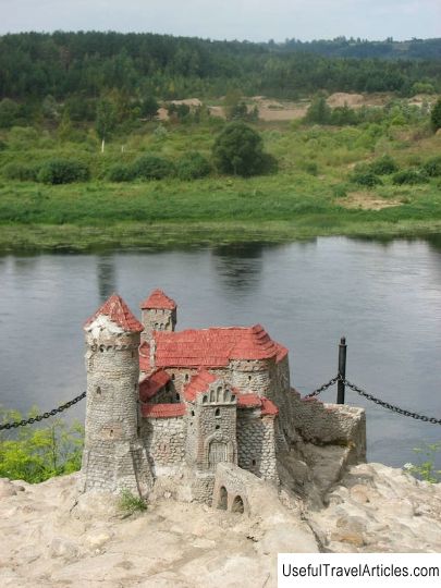
Dabas parks Daugavas loki description and photo - Latvia: Daugavpils. Detailed information about the attraction. Description, photographs and a map showing the nearest significant objects. The name in English is Dabas parks Daugavas loki. Photo and descriptionThe Daugavas Loki Nature Park is located in the Daugavpils and Kraslava regions of Latvia on both sides of the Daugava River. The park with an area of 120 sq. Km was created on February 25, 1990. The purpose of its foundation was the preservation of a unique natural site. When the park was created, the construction of the Daugavpils hydroelectric power station was stopped. In the village of Slutishki there is a pillar to which the water in the reservoir of the Daugavpils hydroelectric power station could rise. The elevation changes in the Daugavas Loki park reach 50 meters, and sometimes even more. So, for example, there is such a place Sargelishki, which is located at an altitude of 160 meters above sea level, and the Daugava, which is located less than 1 km from the village, flows already at an altitude of 90 meters above sea level. the territory of "Daugavas Loki" a large number of streams the largest of them is one of the Daugava tributaries - Melkalne. A little less than 700 plant species are registered in the park. Forests occupy one third of the park's territory. On the territory of the Daugavas Loki Park there are two of the largest cliffs in Latvia. The largest is the Verversky cliff, which is 42 meters high and about 400 meters wide. The Verversky cliff is located on the left bank of the Daugava, 3 km from the village of Slutishki. A beautiful view of Latvia opens from the washdown. The washout occurred after the last ice age. It is mainly composed of gravel. Previously, during strong floods, when the water got close to the edge of the cliff, landslides often occurred. The latter was registered in the early 1920s. Recently, no significant floods and landslides have been observed. What led to the overgrowing of the cliff. The average slope of the Verversky cliff is 38 ˚ C. There are many cultural and historical values in the park. In total, there are 23 valuable archaeological sites: Yuzefovsky, Sikelsky, Spruktsky parishes, the castle of the Rozalishki estate, the settlements Markovo and Vecrachinskoe. In addition, there is a model of the Dinaburg castle on the territory of the park. In the village of Vasargelishki, an observation tower is installed, the height of which is 18 meters. Vecrachinskoe (Starorachinskoe) ancient settlement is located on the right bank of the Daugava, about 2.5 km from the Izvalta railway station. It was first described in 1941 by the hussar Arvid Gusars. The first excavations were carried out only in 1986, led by Tatiana Berga. The settlement, 60x30 meters in size, has the shape of an elongated triangle. To create the settlement, a natural offshoot of the coast was used, in addition, 3 artificial ramparts were created. As a result of the excavations, only a 2-10-centimeter layer of ash was found, no objects indicating the life of people were found. It is assumed that the site is dated to the late Iron Age (X-XIII centuries).         We also recommend reading Pokrovsky monastery description and photo - Ukraine: Kiev Topic: Dabas parks Daugavas loki description and photo - Latvia: Daugavpils. |