Mount Rinjani (Gunung Rinjani) description and photos - Indonesia: Lombok Island
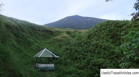
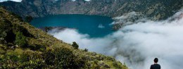
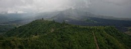
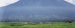
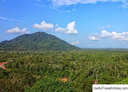
Mount Rinjani (Gunung Rinjani) description and photo - Indonesia: Lombok Island. Detailed information about the attraction. Description, photographs and a map showing the nearest significant objects. The title in English is Gunung Rinjani. Photo and descriptionMount Rinjani is an active volcano located on the island of Lombok. Administratively, the mountain is located in the North Lombok district. This county is one of eight counties within the Western Lesser Sunda Islands (Nussa Tenggara Barat) province. Mount Rinjani, or as its name sounds in Indonesian - Gunung Rinjani, reaches 3726 meters in height. It should be noted that this active volcano ranks second in height among the volcanoes in Indonesia. Gunung Rinjani summit is a large caldera, the size of which is 6 km by 8.5 km. The caldera differs from the crater only in size (the caldera is larger in size) and formation (the caldera is a circus-shaped depression, the crater is most often a funnel-shaped depression). Inside the Gunung Rinjani caldera is a lake known as Segara Anak. In Indonesian, the name of the lake sounds like "Anak Laut" and is translated as "child of the sea" due to the fact that the water in the lake is blue, like in the sea (laut - in Indonesian "sea"). The lake is 2000 meters above sea level, the depth of the lake is about 200 meters. Inside the caldera, in addition to the lake, there are geothermal springs. For local residents - Sasaks, as well as for Hindus, this lake and mountain are considered sacred. Near the mountain and at the top, near the lake, sometimes even religious rites are performed. Around the mountain is the Gunung Rinjani National Park, whose territory is more than 60 hectares. Since 2008, the national park has been taken under the protection of UNESCO. In Indonesian, the name of the lake sounds like "Anak Laut" and is translated as "child of the sea" due to the fact that the water in the lake is blue, like in the sea (laut - in Indonesian "sea"). The lake is 2000 meters above sea level, the depth of the lake is about 200 meters. Inside the caldera, in addition to the lake, there are geothermal springs.For local residents - Sasaks, as well as for Hindus, this lake and mountain are considered sacred. Near the mountain and at the top, near the lake, sometimes even religious rites are performed. Around the mountain is the Gunung Rinjani National Park, whose territory is more than 60 hectares. Since 2008, the national park has been taken under the protection of UNESCO. In Indonesian, the name of the lake sounds like "Anak Laut" and is translated as "child of the sea" due to the fact that the water in the lake is blue, like in the sea (laut - in Indonesian "sea"). The lake is 2000 meters above sea level, the depth of the lake is about 200 meters. Inside the caldera, in addition to the lake, there are geothermal springs.For local residents - Sasaks, as well as for Hindus, this lake and mountain are considered sacred. Near the mountain and at the top, near the lake, sometimes even religious rites are performed. Around the mountain is the Gunung Rinjani National Park, which covers more than 60 hectares. Since 2008, the national park has been taken under the protection of UNESCO. as in the sea (laut - in Indonesian "sea"). The lake is 2000 meters above sea level, the depth of the lake is about 200 meters. Inside the caldera, in addition to the lake, there are geothermal springs.For local residents - Sasaks, as well as for Hindus, this lake and mountain are considered sacred. Near the mountain and at the top, near the lake, sometimes even religious rites are performed. Around the mountain is the Gunung Rinjani National Park, which covers more than 60 hectares. Since 2008, the national park has been taken under the protection of UNESCO. as in the sea (laut - in Indonesian "sea"). The lake is 2000 meters above sea level, the depth of the lake is about 200 meters. Inside the caldera, in addition to the lake, there are geothermal springs.For local residents - Sasaks, as well as for Hindus, this lake and mountain are considered sacred. Near the mountain and at the top, near the lake, sometimes even religious rites are performed. Around the mountain is the Gunung Rinjani National Park, which covers more than 60 hectares. Since 2008, the national park has been taken under the protection of UNESCO. and also for Hindus this lake and mountain are considered sacred. Near the mountain and at the top, near the lake, sometimes even religious rites are performed.Around the mountain is the Gunung Rinjani National Park, which covers more than 60 hectares. Since 2008, the national park has been taken under the protection of UNESCO. and also for Hindus this lake and mountain are considered sacred. Near the mountain and at the top, near the lake, sometimes even religious rites are performed.Around the mountain is the Gunung Rinjani National Park, whose territory is more than 60 hectares. Since 2008, the national park has been taken under the protection of UNESCO.      We also recommend reading National Museum of Art description and photos - Mozambique: Maputo Topic: Mount Rinjani (Gunung Rinjani) description and photos - Indonesia: Lombok Island. |