Waterfall on the Chapoma river description and photo - Russia - North-West: Murmansk region
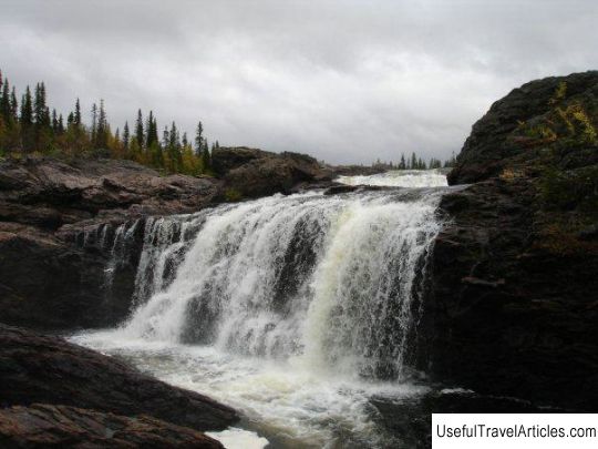
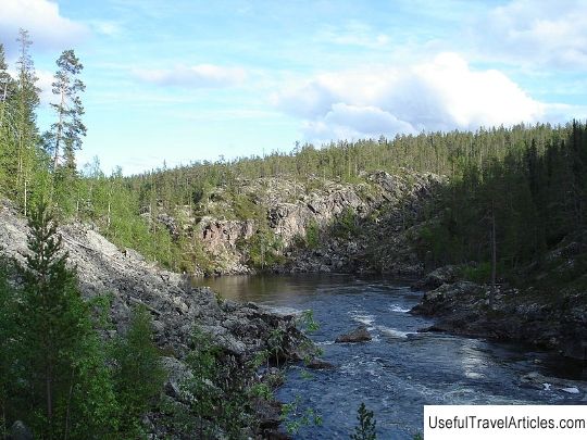
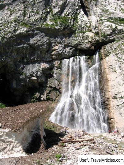
Rating: 8,1/10 (2839 votes) Waterfall on the Chapoma river description and photos - Russia - North-West: Murmansk region. Detailed information about the attraction. Description, photos and a map showing the nearest significant objects. Photo and descriptionOne of the largest and most popular waterfalls in the Murmansk region is the waterfall on the Chapoma River, which is a state hydrological natural monument of the Kola Peninsula. The waterfall is located in the southeastern side of the Kola Peninsula, namely on the territory of the Tersk region, on the beautiful Chapoma river, which is 8 km north of the river mouth. On January 15, 1986, a waterfall on the Chapoma river was awarded the title of the monument, which happened according to the order of the Murmansk Regional Executive Committee No. 24. The idea of creating a natural monument appeared on the occasion of the appearance of the proposal by I.I. and Klyueva R.F., which sounded in 1980. The channel of the Chapoma River, as well as the completely adjacent coastal area, one kilometer from each river bank, is subject to state protection. The area of the protected area is 200 hectares. The waterfall is not only of nature conservation, but also of aesthetic value. On a section of the protected area, there is a similar and standard regime for this kind of objects, according to which felling, various production works, as well as tourism or any similar activity that may lead to pollution of the waterfall. The guarantor of this object was a regional state institution called "Directorate of PAs of regional significance in the Murmansk region." The Chapoma River flows through the territory of the Tersk and Lovozero districts of the Murmansk region. Chapoma belongs to the rivers located in the southeastern side of the Kola Peninsula and flows into the famous White Sea. The total length of the river is 113 km, and the total catchment area is 1110 sq. km. It is on this river that the village of the same name is located, as well as other settlements. Some tributaries flow from the source and to the mouth of the Chapoma River - Komariy, Yuzhnaya Razvila Chapomy, Travyanoy, Zapadny Black, Labazovy, Maslovsky and Pavlosky. As the river moves through Chapoma lakes, its channel becomes more and 150 km. It should be noted that in Chapoma there are such fish as salmon and brown trout, which passes the river twice a year - in winter and in summer. The waterfall on the Chapoma river is the most large not only in length, but also in height of the fall of water from all available on the Kola Peninsula. The waterfall consists of several rapids, which are composed of ledges, on the highest of which water falls from a height of 20 meters. In this place, the flow of the river is especially stormy and fast, which is associated with a huge number of large boulders and blocks resting on the bottom of the Chapoma River. Fairy tales rise right above the river banks, which form in this place a medium-sized, but especially picturesque canyon. It should be noted that for 500 m the waterfall forms a sharp difference in heights of about 30 m. In the area of the monument there is a large amount of vegetation, represented by taiga forests, moss layer, grass-dwarf shrub layer and an impressive number of bizarre epiphytic lichens ... The most common plants are forest geranium, forest horsetail, cloudberry, and hellebore. As for rare plants that are listed in the Red Book, it is worth noting the Maryin root or deviating peony. Scientific research works are regularly carried out in the area of the natural monument. For example, in the summer of 2003, all the territories adjacent to Chapoma were thoroughly investigated by the chief researcher N. Ts. Koroleva, who established an important threat in this area concerning the extinction of the Maryin root peony growing here and especially rare for the Kola Peninsula. On the initiative of one of the regional TV companies of the Murmansk region, in 2009 with the participation of the Ministry of Ecology and Natural Resources of the Murmansk Region and the branch of the Murmansk Wildlife Fund, the competition "Seven Wonders at the End of the World" was held, following which seven of the best and most remarkable objects of the Murmansk region. A waterfall on the Chapoma River was also mentioned among potential candidates.          We also recommend reading Old Treffen castle ruins (Burgruine Alt-Treffen) description and photos - Austria: Treffen Topic: Waterfall on the Chapoma river description and photo - Russia - North-West: Murmansk region. |