Gorny Altai
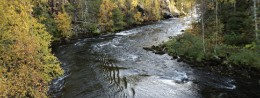
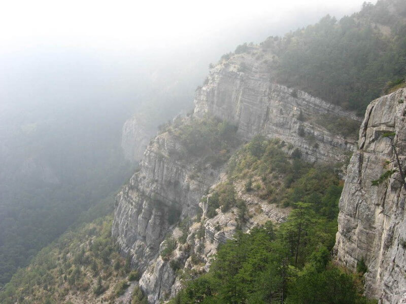
Rating: 9,6/10 (2454 votes) 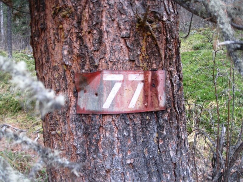 Tourist Route 77 The once legendary all-Union tourist route number 77 was known in all the republics of the vast country. Every year hundreds of thousands of specially trained tourists come to Gorny Altai to pass incredibly difficult and picturesque pipes. After many years of neglect, this route is again gaining popularity among Russian tourists. History of the routeFor the first time, we learned about tourist route No. 77 in 1956. It was created to support the Altai region and the development of professional tourism throughout the Soviet Union. Even then, its length was determined - almost 800 kilometers taking into account the walking part, rafting and transfers. The third category of complexity was not given to the route by chance - only physically prepared tourists, ready for long transitions, could go on it. The average duration of the Soviet route was 18 days, it was soon announced minimal. On average, even for well-trained groups, it took at least 22 days to complete the route. Tourists almost half of the declared 800 kilometers had to walk on foot, the rest of the distance was covered by yachts and trucks plying between tourist centers. In fact, the route existed for almost 33 years. With the beginning of perestroika, the question of closing it arose more than once, but the demand among experienced tourists for some time supported this direction. The final decision to close the route was made in 1992. The revival of tourist route No. 77 took place in the 2000s. Only by 2010, groups of tourists began to gather along a well-organized route based on the legendary Soviet paths. Organization of groupsAs well as half a century ago, route number 77 begins in the Altai Territory , in the city Biysk. The preparatory stage takes from 2 to 3 days, depending on the size of the group. During this time, guests are not only instructed on the upcoming exit, but also introduced to the city, arrange an excursion to the sights of Biysk. After that, the direct organization of the departure begins.  Biysk Tourists will need to pack a backpack with a change of linen, at least two jackets, woolen socks, a sleeping bag and a raincoat. This is done because of the changeable and unpredictable Siberian weather. The average weight of a backpack for such a serious hike can be 20-25 kilograms. After collecting everything necessary and checking the equipment, the group gathers on departure. Tourists are taken out of Biysk in cross-country vehicles. The starting camp is located 250 kilometers from Biysk in the village Edigan.  Edigan Description and durationCurrently, the optimal duration of route 77 is 13 days. There is a debate among tourists whether the route has become easier than the Soviet version or not. Supporters of the second point of view argue that the shortening of the waterway has led to an increase and complication of the walking part of the trip. The length of the walking part is 167 kilometers. 1 dayA group of tourists have breakfast in Edigan, distribute the necessary things to their backpacks, leaving the excess at the base. Things are brought to the final point of the route in an organized manner. You don't have to worry about them. After that, the group goes on the first leg of the path. It is also considered the most difficult - in front of the group there is a long climb uphill to a height of more than a kilometer. The trail passes through the Terbiyan tract and the Kyzyl-Gak tract. In the latter, a halt is arranged. The length of this section of the route is 19 kilometers.  Kyzyl-Gak tract Day 2From this day, overcoming the passes begins. Tourists pass through the Tamanol Pass past the famous pyramid made of stones, considered here the sacred altar of the owner of the mountain. Further the path passes through the source of the river Chemal, the river valley Toguskol. This place is popular with independent tourists, so it can get crowded during the height of summer. On the second day, the group travels 12 kilometers.  Chemal River Day 3The third day is almost entirely devoted to overcoming the Soigonosh Pass. The ascent to it, despite the height difference of almost 2 kilometers, does not seem too tiring, but the descent will turn out to be steep and in some areas - dangerous. It is especially dangerous here in rainy weather, when there is a risk of slipping and falling on sharp stones. The difficulty of the passage pays off for the picturesque views - there are many waterfalls with clear water. The length of the section will be 15 kilometers. Day 4For the fourth day, the group must pass the Tyurdem tract and the pass of the same name. This section is difficult because the slopes of the pass are clayey and very slippery even in good weather. The length of the crossing is approximately 15 kilometers.  Turdem Tract Day 5For the fifth day, tourists overcome the Bezymyanny Pass and its surroundings. Here are dense cedar forests surrounded by meadows. The trek to 15 kilometers ends with a halt on the shore of Blue Lake.  Blue Lake Day 6The sixth day is dedicated to the passage through the Uymensky Pass from the source of the river Aksaazkan. The icy mountain river will have to wade. The goal of the passage to 12 kilometers is the lake Uymen.  Lake Uymen 7 dayA day off is planned for the seventh day of the route. The shore of Lake Uymen is a quiet place where you can sleep, fish or play active games. It is worth rest, as it should - the next two days will be the most intense on the entire route. Day 8The Uymen River, flowing out of the lake, will become a landmark on the trail to the Karasaazkan Pass. After it, the group will be waiting for the camp"Before the Tripod". The road to the camp from the river will be 16 kilometers. Day 9Tripod Pass is the most difficult and dangerous section of route 77 ... The steep slopes of the mountain will require the most coordinated actions from the group and even some mountaineering skills. The descent will also be very difficult - the eaves are very narrow, the risk of rock falls is high. The length of this segment is almost 19 kilometers. Day 10After rest, you need to prepare again for a long trek - 24 kilometers - true , this section has less complexity. The section can be called an exit to the Teletskoye Lake, but ahead of the Sinyrlu pass. Only after descending from it it will be possible to arrange a long-awaited halt. Day 11The last big pass will be Kyzyltash. The approach to it is not easy - the group will have to wade through several rivers. The descent from it is serpentine, after that a halt is made not far from the hunters from the village of Balykcha. The segment is 18 kilometers long.  Kyvyltash pass 12 dayThe last pass - Tanys - surrounds many places memorable for the Altai people. Here you can see the Shaman-Tree known according to folk legends. The opening view of Lake Teletskoye is preceded by a serpentine descent and a halt in Balykche. 17 kilometers here can be called the easiest for the entire route - almost half of the way is a rural road. Day 13On the last day of the route from Balykchi, the group goes to the camp site Kyrsay, where he sits on motor boats at the pier and sets off on a journey across the clear water surface of the Teletskoye Lake. Almost 80 kilometers of the water section of the path is covered for a long time - there are many stops at waterfalls ahead. In the evening, tourists are delivered to the village of Artybash, from where they travel back to Barnaul and Biysk by buses.  Artybash We also recommend reading Ghost town of Kraco (Italy) Topic: Gorny Altai. |