Fortress Kalamita description and photo - Crimea: Sevastopol
Rating: 7,7/10 (343 votes) 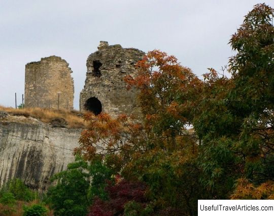
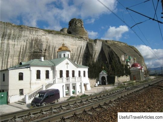
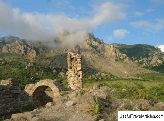
Kalamita fortress description and photos - Crimea: Sevastopol. Detailed information about the attraction. Description, photos and a map showing the nearest significant objects. Photo and descriptionThe ancient medieval fortress Kalamita is located in the city of Inkerman. Its ruins are located on Monastyrskaya Hill - at the mouth of the Chernaya River, and the surviving parts of the Christian cave monastery have been preserved in the lower part of the mountain. All these ancient structures are part of the complex of the branch of the national reserve `` Tauric Chersonesos. '' According to historians, the original fortification was erected on the Monastery rock in the early Middle Ages. At that time, Byzantium was building fortresses around Kherson, fearing the threat of nomadic raids on the southwestern part of Crimea. Written sources have not preserved information about this fortification. For the first time the name `` Kalamita '' was discovered on a Genoese nautical map published in 1474. Earlier, on the maps of Italian cartographers of the 13th and early 14th centuries, this place was called Gazaria and Kalamira. Prince Theodoro Alexei erected a fortress in 1427 to protect the only port of the Theodorites called Avlita, located at the mouth of the Black River. The princes Theodoro carried out such a lively trade through the Kalamite port that they became a dangerous competitor for Kafa. In the Genoese instruction of that time, dedicated to the management of the Black Sea colonies, it is written that the Mangup princes, disregarding the rights and privileges of Kafa, openly built a harbor in Kalamita. And by loading and unloading merchant ships in it, they damage the taxes collected by Kafa. The Tatars actively used the Kalamitsky port to sell slaves to the Turks. Turkish army, landing in the summer of 1475 in the southeastern Crimea and capturing the Genoese colonies, she approached Mangup. The capital of the principality fell in December 1475, unable to withstand a long siege. Kalamita was captured by the Turks a little earlier. The fortification on the Monastic Rock was named by the Turks In-Kermen (Inkerman). Translated from Turkish, it means “cave fortress”. At the turn of the XVI-XVII centuries, they rebuilt the fortress for military operations in the new conditions of the use of firearms. Back in the 17th century, commercial life was in full swing in the port, but by the middle of the 18th century the military and commercial significance of the fortress and the port of Kalamita was lost. The fortification on the Monastic Rock was named by the Turks In-Kermen (Inkerman). Translated from Turkish, it means “cave fortress”. At the turn of the XVI-XVII centuries, they rebuilt the fortress for military operations in the new conditions of the use of firearms.As early as the 17th century, trade life was in full swing in the port, but by the middle of the 18th century the military and commercial significance of the fortress and the port of Kalamita was lost. The fortification on the Monastic Rock was named by the Turks In-Kermen (Inkerman). Translated from Turkish, it means “cave fortress”. At the turn of the XVI-XVII centuries, they rebuilt the fortress for military operations in the new conditions of the use of firearms.     We also recommend reading Festival and Congress Center description and photos - Bulgaria: Varna Topic: Fortress Kalamita description and photo - Crimea: Sevastopol. |