Pellotsaari island description and photos - Russia - Karelia: Pitkyaranta district
Rating: 8,3/10 (1849 votes) 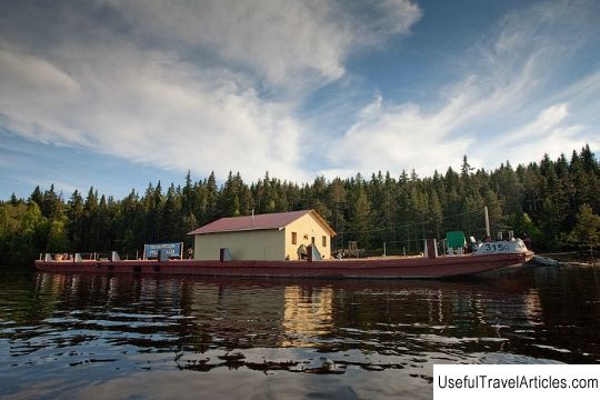
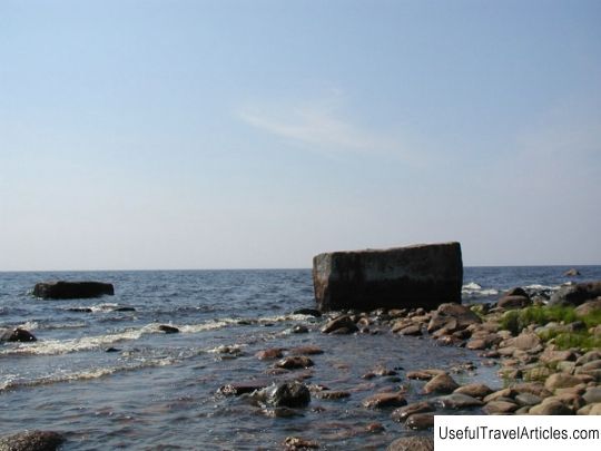
Pellotsaari island description and photos - Russia - Karelia: Pitkyaranta district. Detailed information about the attraction. Description, photos and a map showing the nearest significant objects. Photo and descriptionThe island of Pellotsaari is located in the Ladoga skerries, just a few kilometers from the mainland and 22 km from the famous island of Valaam. The Ladoga Skerries are a picturesque archipelago of small rocky islands located in the coastal zone in the north of Lake Ladoga - it was here that the formation of the famous national park "Ladoga Skerries" was planned. The water line from Pellotsaari to Valaam is 24 km. If you follow the cruise route, the sailing time from Valaam to Pellotsaari will be about an hour and a half. The size of the island is small: it is 3 km wide and 4 km long. At the moment, the famous island is popular exclusively for those (especially among the most active tourists), that in the Ladoga area you can travel by boat or motorboat. In the coming time, it is planned to organize a special parking lot for motor ships, and to open the island for mass and widespread visits by tourists. Now the island has a restored and updated ship parking. Several motor ships can swim to the berth at the side mooring at the same time. As for the duration of the stay of pleasure and cruise ships, parking on the island is allowed for 5-6 hours. On the island of Pellotsaari, there is also a well-equipped pedestrian loop trail. It is also called an ecological path. Its total length is about 3 km, and the approximate time that will be spent on its full study will be about 3 hours. On the ecological walking trail there are signs of 28 natural objects. The territory of Pellotsaari is beautifully arranged, all its paths have been cleared, steps have been made in the places of ascent, and special bridges have been laid over especially swampy places. As you know, the island of Pellotsaari used to be part of the possession of Finland, and since then the island has survived some foundations of houses of Finnish, Russian and Swedish families who lived here until the middle of the 20th century. A school was discovered on the island, as well as a pier designed for large ships. Once on the island of Pellotsaari, mining was carried out for mountain quartzite; now a tourist route leads to the stone quarries. Of particular interest is the fact that quartzite faults are completely flooded, forming almost bottomless bowls filled with icy clear water. The island has a picturesque and untouched beach with a beautiful view of Lake Ladoga, as well as the island of Valaam. In addition, Pellotsaari Island is a taiga island, the abundant vegetation and landscapes of which are largely due to the activity of the glacier that retreated from the Ladoga area about 10-12 thousand years ago. Small size the islands do not in the least affect the diversity of landscapes, flora and fauna. On Pellotsaari, you can look into hidden corners of nature, almost untouched by human activities, and there are also landscapes that have changed under the influence of human economic activities. Almost the entire territory of the Pellotsaari Island is covered with dense forests dominated by coniferous trees. There are also meadows on the island, which are one of the amazing ecosystems related to the Ladoga skerries. The most widespread community is represented by rock plants, and some of them are listed in the Red Data Books of Russia. An active change in the nature of Pellotsaari began to occur since the 16th century, when people increasingly began to develop their livestock activities and agriculture. In the south-west of the island, not only the foundations of houses of different nationalities have been preserved, but also the foundations of outbuildings, various fragments of hedges, the ruins of detached buildings, reclamation ditches, as well as traces from the planting of certain types of vegetation. In the rest of the Pellotsaari island, the original appearance of the taiga forest is slowly recovering: roads disappear, agricultural lands are overgrown with vegetation.          We also recommend reading Prevlaka Island (Flower Island) (Prevlaka) description and photos - Montenegro: Tivat Topic: Pellotsaari island description and photos - Russia - Karelia: Pitkyaranta district. |