Ragusha river valley description and photos - Russia - Leningrad region: Boksitogorsky district
Rating: 8,0/10 (765 votes) 
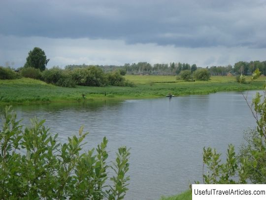
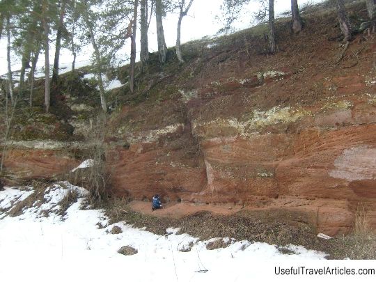
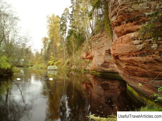
Ragusha river valley description and photos - Russia - Leningrad region: Boksitogorskiy district. Detailed information about the attraction. Description, photos and a map showing the nearest significant objects. Photo and descriptionThe formation of the complex natural monument "Ragusha River" took place in 1976. It is located in the village of Rudnaya Gorka in the Boksitogorsk district of the Leningrad region. You can get to the natural monument from the city of St. Petersburg to Boksitogorsk and further, passing through the river, between the villages of Rudnaya Gorka and Glina. The complex monument "Ragusha River" has the status of a natural monument created for the purpose of preserving Ragusha from its unique karst landscape, rock outcrops, a canyon-shaped valley, as well as diverse and unique vegetation. The geological structure of the unique valley of the Ragushi River, first of all, is due to limestones, which were formed in the Carboniferous period. Limestones have a somewhat fractured character and emerge on the earth's surface, which creates suitable conditions for the process of leaching of readily soluble limestone rocks, which form a large number of craters, including even sinkhole craters. The river valley is especially winding and almost completely overgrown trees and shrubs. Not far from the bridge leading across the river to the village of Rudnaya Gorka, the valley is almost completely covered with huge fragments of limestone, which have come off the rocks above. At the bottom of the bridge there is a canyon with gentle banks, the height of which reaches more than 8 m. The cliffs of gray-yellow limestone rocks are located almost vertically, which makes an unforgettable impression. In some places the rocks are cut by large cracks, and somewhere there are niches that form deep caves. The upper reaches of the Ragushi are very similar to the upper reaches of medium-sized rivers in the northwestern part of Russia, which is manifested in the formation of shallow valleys, as well as a slow flow of water flow among spruce forests. The section of the river bed, where the village of Rudnaya Gorka is located, is filled with water in the spring and autumn seasons. The lower part of the river valley is characterized by intensive discharge of water through the voklyuz - ascending springs. Along the area of development of karst processes, the river valley acquires a canyon character, while the height of the sides reaches almost 60 m. The banks of Ragusha in this part are steep, somewhat indented by streams, and sometimes you can see small waterfalls. In some places, the canyon slopes are dotted with limestone fragments, on which jasper-like nodules are visible. The flora of the Ragusha River is no less diverse and unpredictable. The sides of the valley are dotted with broad-leaved and alder forests, rare for this area, which are presented in the form of various floristic complexes, such as nemoral, taiga and some others. Here you can see a broadleaf bell, giant fescue, and mosses grow on the rocks. But the most beautiful representative of the flora of the protected area is the forest orchid or lady's slipper. The river is an excellent spawning ground for certain species of trout. The upper reaches of the marshes are especially rich in representatives of the local fauna: the medium curlew and the common crane. In addition, the largest number of grouse birds is represented here. A special pride of the natural monument is the dipper nesting grounds, and in the upper reaches of the Ragushi there are beaver settlements. Almost the entire area of the natural complex is favorable for elks, wild boars, raccoon dogs, wolves, foxes, hares, badgers and even brown bears. The territory of the complex monument is strictly prohibited: land reclamation, plowing of land, any interference with the hydrological regime of the natural zone, geological surveys, the laying of all types of communications, the use of pesticides and toxic chemicals, littering of the territory and water area, as well as hunting and parking. Today there are plantations along the perimeter of the Ragushi channel in the form of a forest strip, the width of which reaches 15 m, which was created in order to protect the river reservoir. Government of the Leningrad Region, or rather, the Committee for the Protection of the Environment and Natural Resources is called upon to preserve a unique natural corner, including its inhabitants.     We also recommend reading Fort Thungen description and photos - Luxembourg: Luxembourg Topic: Ragusha river valley description and photos - Russia - Leningrad region: Boksitogorsky district. |