Fortress Yeni-Kale description and photo - Crimea: Kerch
Rating: 8,6/10 (2093 votes) 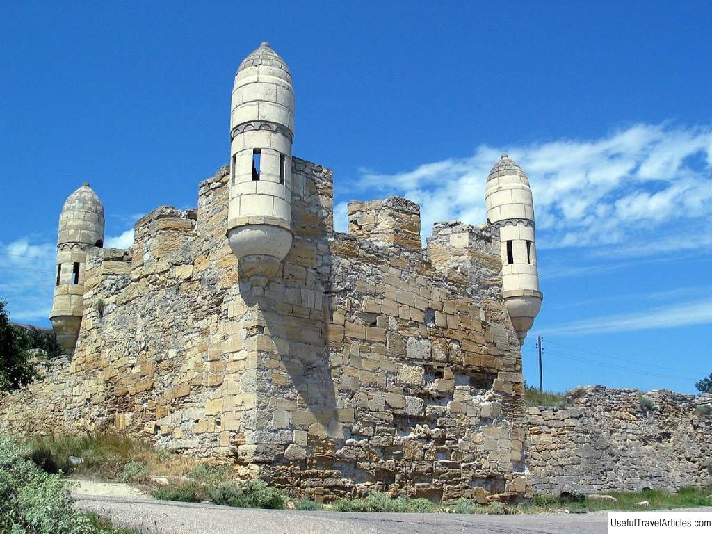
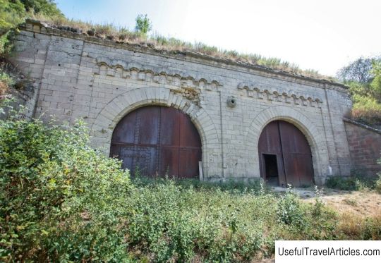
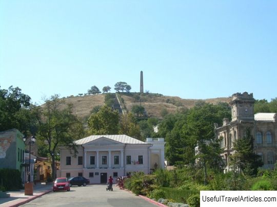
Yeni-Kale fortress description and photo - Crimea: Kerch. Detailed information about the attraction. Description, photos and a map showing the nearest significant objects. Photo and descriptionThe fortress, built by the Turks in the 18th century, once protected the Kerch Strait and the passage to the Sea of Azov. Now it is a picturesque ruin on the outskirts of Kerch with partially preserved bastions. History of constructionIn the 18th century, the territory of Crimea was owned by the Ottoman Empire . In the XV-XVII centuries, it was the largest and most influential state in the Mediterranean. It occupied almost the entire territory of the former Byzantium: North Africa, Greece, all of Asia Minor. Many countries were under her influence. For example, Crimean Khanate is a state that was the "heir" of the Golden Horde, and the Italian colonies of the Northern Black Sea region came under the influence of the Ottoman Empire since the 15th century. In 1475 the Turks landed in the Crimea, captured the Genoese colonies and forced the then Crimean Khan - Menli Giray - to admit his dependence on the horde. It was then that the territory of the Kerch Strait became part of the Ottoman Empire. At the very beginning of the 18th century, the Turks built here the Yeni-Kale fortress to protect the Kerch Strait. “Yeni-kale” is literally translated as “new fortress”. The old fortress was also here once. It was called Kilisejik . By the beginning of the 18th century, only ruins and foundations remained from it - the fact is that it was blown up back in 1631 during one of the clashes with the Zaporozhye Cossacks. But the fortress at the narrowest point of the strait was vital for the Turks: it controlled the passage for ships to the Sea of Azov. We know the name of the architect - it was Italian Goloppo . Not much is known about him - we also know that he not only offered his job as an engineer by the Turks, but converted to Islam. He built the fortress in French traditions. It is a pentagon with five semi-bastions and is located on the side of a mountain, that is, it has several levels. A moat surrounded the powerful walls. The fortress could accommodate up to a thousand people of a permanent garrison and occupied two and a half hectares. It contained everything necessary for life: a mosque, baths, arsenals, powder stores. The construction was not limited to the fortress - under the fortress by the sea there was a small port , and a vast settlement grew up around the fortress. For, to distinguish them, it is customary to write the name of the fortress through a hyphen - Yeni-Kale, and the city and nearby territories together - Yenikale. The only major drawback was dependence on fresh water . The fortress had its own small well, but it could not provide the entire population with water. The water reservoirs were filled with water from a source that was located quite far away and outside the walls. Water entered Yeni-Kale through karmic pipes. Russian-Turkish warIn the 18th century, the growing confrontation between the Ottoman Empire and Russia turned into a war. Russia needed to get access to the Black Sea. However, the war began not with a direct clash of the two powers, but with a dispute over Poland. Troubles broke out in Poland, Russia intervened and sent troops there. And then the Bar Confederation, formed by the Polish Catholic gentry, which categorically opposed Russia's interference in their affairs, turned to Turkey for support. The diplomatic crisis came at a time when hostilities between Russia and the Confederates spilled over into Turkish territory, in Balta and Dubossary. In 1768 war was declared. It began with the raids of the Crimean Tatars to Novorossiya (and at the same time to Polish territories), and from the Russian side - from the occupation of Taganrog. The Russian army was better armed and prepared, and although the commander-in-chief Golitsyn preferred to act with caution and defend more, several victories followed. For example, in August the fortress Khotin was taken, practically without a fight - the Turks simply left it, and the Russian garrison had to bury their dead. During 1770, the Russians continued to win in the territory of Moldova and southern Russia. The battles were not only overland. In July 1770, the Russian fleet defeated the Turkish in Chesme Bay . This is one of the greatest victories of the Russian fleet in general, a day that has long been remembered. 1771 was marked by military operations in the Crimea. On the Turkish side, it was mainly the troops of the Crimean Khanate allied with Turkey that opposed us. In June, the Russians captured Perekop . The Tatar troops retreated to Feodosia , and the Crimean dignity himself left the Crimea altogether, took refuge in Constantinople. June 21, 1771 a detachment commanded by the prince Fyodor Fedorovich Shcherbatov , first occupied Kerch, and then - the Yeni-Kale fortress. The Turks surrendered the fortress without a fight, leaving almost all the artillery here. It turned out that the fortress, which was supposed to protect the strait from the enemy fleet, was occupied from land. In 1772, a peace agreement was concluded between the Crimean Khanate and Russia. This happened in the city Karasubazar (now it is Belogorsk). The Crimean Khanate remained independent, but passed under the patronage of Russia, and the territories of Kerch and Yenikale became Russian. It turned out that these places became the very first Russian possessions in Crimea. In Kerch, almost immediately began to build another fortress. Now it is Kerch Fortress on Cape Pavlovsky . But Yeni-Kale continued to maintain its importance for the control of the strait. The Russian-Turkish war was ended only in 1774. In the town of Kuchuk-Kaynajir , a peace agreement was signed between the Russian and Ottoman empires. This treaty confirmed the agreement of 1772: neither Turkey nor Russia interfere in the affairs of the Crimean Khanate, and the territory of Kerch and Yenikale goes to Russia. Despite the terms of the treaty, Crimea remained a territory claimed by both empires. Turkey did not withdraw its troops from Crimea, Russia brought in its troops. The Crimean Tatar nobility supported the idea of returning under the auspices of the Ottoman Empire. Two pretenders fought for the khan's throne - the Russian protege Shahin-Girey and the old khan Davlet-Girey . Shahin-Girey established himself on Taman, but soon with allied Russian troops landed at the Yeni-Kale fortress, and then took the throne. He tried to rule in a European way, change old customs, carry out reforms, but at the same time he was distinguished by cruelty and harshness of character. As a result, in 1777 an uprising was raised against him, which had to be suppressed by the Russian troops led by Alexander Suvorov . In all the fortresses (including Yeni-Kale) Russian garrisons settled. In 1779 a new agreement was reached with Turkey. Shahin-Girey became the Crimean Khan, and Russian troops were withdrawn from the Crimea. The garrisons remained only in our territories: three thousand people each in Yeni-Kala and in Kerch. But four years later, after a new uprising and the abdication of Shahin-Giray, Crimea was finally annexed to Russia. A small town with a fortress in it is gradually beginning to be perceived as a satellite town of Kerch. Here in 1797 the baroque Trinity Church was built. Since 1825, the fortress finally loses its strategic importance and becomes a fortified hospital . During the Russian-Turkish war, the hospital successfully fired back from the fortress from the allied landing, and the fortress was not surrendered. But by the 1880s, the hospital was dilapidated and no longer needed. The fortress turned out to be abandoned, and the fishing village under it, which then had four thousand inhabitants, also began to wither slowly. The fortress at the present time The town of Yenkale was an independent formation until 1968. In 1948 it was renamed the village Sipyagino , and in 1968 it became part of the expanding Kerch. The Trinity Church was blown up in 1935 During the Great Patriotic War, the fortress again became a military target, a group of partisans defended in it for a long time. In general, there are many catacombs under Kerch: these are natural caves, and numerous remains of ancient burials, which are also caves, and underground passages. During the occupation, a fierce struggle against the Nazis ensued here, and the catacombs served as shelter for partisan groups. The Yeni-Kale fortress was convenient for shelter. There are still working water tanks in it. In 1943-44, battles with the Nazis were fought here. As a result of the Kerch-Eltigen landing operation these territories were the first to be liberated - and became a bridgehead for the Soviet troops, from which the rest of Crimea was cleared of the invaders. Now several picturesque fragments have survived from the fortress: three gates, a one-story hospital building . The most famous and beautiful part is the bastion with towers right next to the sea above the Kerch Gate. A railway was built through the territory of the fortress; the rampart served as its embankment. It is this road that leads to the crossing over the strait. In Soviet times, a small restoration was carried out, part of the territory was cleared, but in general, the fortress is now in ruins. On the one hand, it is difficult to imagine its historical appearance now, but on the other hand, it provides a unique opportunity to freely climb over the ruins and remnants of walls. At the very cape, which is called that - Cape Lantern , there is a lighthouse. The lighthouse itself existed here since the 1820s, but the old building was blown up during the war: the lighthouse was defended and diverted the attention of German artillery from the Taman side. However, already in 1944, a temporary beacon was installed using some of the old equipment. Immediately after the war, it was a twenty-meter wooden tower with a lamp compartment at the top. The current snow-white lighthouse was erected in 1953. Next to the lighthouse there is a memorial , erected in 1944 in memory of the liberation of the cape and surrounding areas from the Nazis.          We also recommend reading Mausoleum of Ataturk (Anitkabir) description and photos - Turkey: Ankara Topic: Fortress Yeni-Kale description and photo - Crimea: Kerch. |