Lake-channel system of the Big Solovetsky Island description and photos - Russia - North-West: Solovetsky Islands
Rating: 7,7/10 (5494 votes) 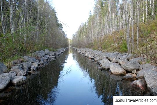
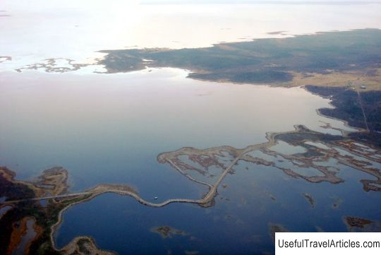
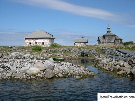
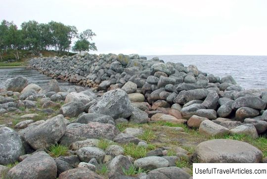
Lake-channel system of Bolshoy Solovetsky Island description and photos - Russia - Northwest: Solovetsky Islands. Detailed information about the attraction. Description, photos and a map showing the nearest significant objects. Photo and descriptionThe lake channel system is one of the most unique sights of the famous Solovetsky Islands. Many people know that there are about 400 lakes on the Solovetsky Islands, and the water levels in them are radically different from each other. For example, two neighboring lakes - Lapushechnoye and Zelenoye - have completely different water levels, the difference between which is about 20 m, and the difference between Gremyachy and Krasnoye lakes is 13 m. There are quite deep lakes on the islands, the depth of which reaches the mark in 25 m. From the moment the construction of the Solovetsky Monastery began, all more and more people arriving in these places required a greater amount of fresh drinking water. It is for this reason, in the absence of rivers, the settlers decided to connect the existing lakes with the help of canals. The lake-channel system of the Big Solovetsky Island was created four centuries ago under the clear leadership of one of the abbots - Philip. During the creation of the system, 78 lakes merged into one system, which fed the Saint Lake. Many monks knew about the difference in water levels in the lakes, so they connected the lakes with canals, while directing the flow of water by gravity directly into the Holy Lake, which is still the holy source of the entire water supply of the village. From this place, through an extensive underground canal, water is supplied to the territorial zone of the monastery, while the water was used for water supply and was fed to the millstone, after which it entered the sea by passing through the lock. Throughout the 19th century, canal water operated a small power plant as well as equipment from a local sawmill. Today, the canals are mostly destroyed or littered. During the late 19th - early 20th centuries, another lake-channel system was built on Bolshoy Solovetsky Island, which later became known as "navigable". The construction of this system became literally a necessity, because it was necessary to increase the flow of water into the Holy Lake in order to increase the productivity of the water mill, as well as the planned construction of a hydroelectric power station. It should be noted that the water system had to be very convenient and pass between the hermitages of the monastery and the deserts. During the construction of such a system, several locks were formed, which allowed even large ships to pass through the created channels. Hay, bricks, stones, firewood and many other necessary materials were transported through such channels. In most places, parts of the wooden quays for ships have survived. Today on the islands there are about twenty separate lake-channel systems, the most important of which is the system of the Holy Lake. A boat pass runs along a small circle of the Solovetsky lake-channel system, a walk along which takes about six hours. During the walk, tourists will be able to learn about the hydrotechnical monuments and other structures of the largest of the islands. The route passes through five man-made canals that connect five lakes. Tourists will have the opportunity to try paddling themselves, replacing each other. The water route starts from the boat station, which is located in the northern side, which is 1.5 km from the Kremlin. In order to make a large circle, it will be necessary to spend much more effort, because the number of hours spent the trip will be approximately 10 hours. During the excursion, tourists will get acquainted with the hydraulic monuments, take a walk along the canals that already connect six lakes. The length of the walk is 18 km, but most often part of this distance is given for walking, especially for Sekirnaya Gora, which is located far from the most distant point of the route. From the elevated platform, you can see some part of the Big Solovetsky Island, as well as the White Sea. As the route progresses, tourists learn about the historical development of the Svyato-Voznesensky skete and the punishment cell for prisoners.        We also recommend reading Novodvinskaya fortress description and photo - Russia - North-West: Arkhangelsk Topic: Lake-channel system of the Big Solovetsky Island description and photos - Russia - North-West: Solovetsky Islands. |