Xunantunich description and photos - Belize: Cayo
Rating: 8,3/10 (6589 votes) 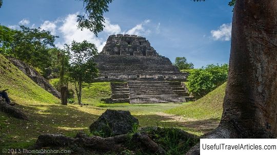
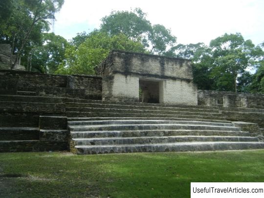
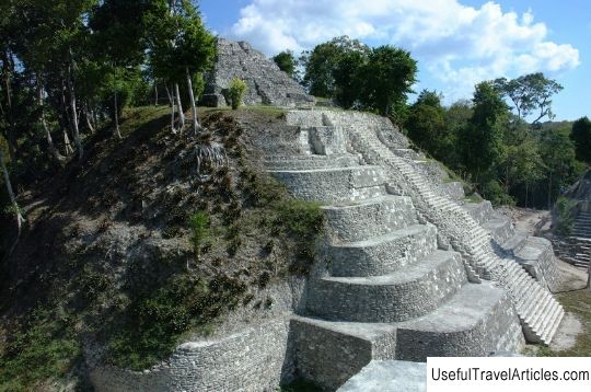
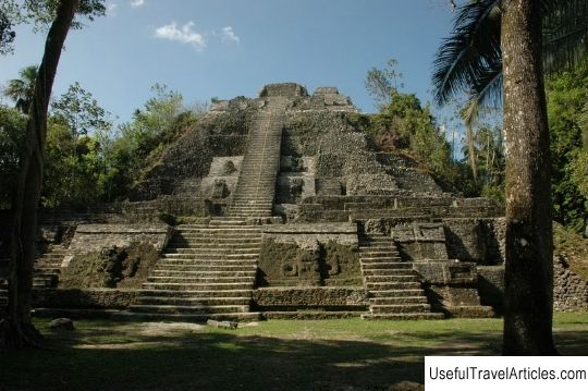
Xunantunich description and photos - Belize: Cayo. Detailed information about the attraction. Description, photographs and a map showing the nearest significant objects. The title in English is Xunantunich. Photo and descriptionShunantunich is an ancient archaeological site of the Mayan civilization, located 130 km west of Belize City, in the Cayo region, located at the top of a ridge above the Mopan River valley. The settlement served as a public ritual center for the Maya at the end of the classical period. The name “shunantunich” is translated from the Yucatec dialect as “stone woman”. This is a modern name; the ancient name has been lost. According to legend, the "stone woman" is a white ghostly figure with red fiery eyes, appearing on the stone staircase of El Castillo and disappearing into the wall. The center of Shunantunich city occupies about 2.6 sq. Km, consists of six squares surrounded by cult buildings and palaces. On the territory of the state of Shunantunich, there are 140 mounds per square kilometer. One of the most famous structures is the El Castillo pyramid. The El Castillo Pyramid is the second tallest ancient structure in Belize (40 m high). El Castillo is the “axis of the world”, the intersection of the city's two central lines. Scholars suggest that the temple was built in two stages; the first dates from about 800; had five exits at different levels. The pyramid consists of a series of stepped terraces, finished with fine stucco. The images on the surviving friezes are varied. Found bas-reliefs depicting the birth of God, and the tree of life growing from the underworld to heaven, the royal family. The ritual space was reserved for the elite only, and was separated from other public places. Until the seventh century, the settlement consisted mainly of farmers. Thanks to the fertile soils and high population density, the villages were economically self-sufficient, which was the reason for the prosperity of Shunantunich. The natural closure of the area contributed to the fact that at a time when most of the Mayan civilizations fell into decay, Shunantunich was able to expand its influence to other areas of the valley. There is evidence that the city was the center of socio-political administration in the upper part of the valley. Lavish religious and funeral rites and various ceremonies for the ruling caste were held on the pyramid. The first exploration of the area was carried out by the British surgeon and Commissioner of the Cayo District Thomas Gunn in the mid-1890s. His successor, Sir J. Eric S. Thompson, systematized the approach to research, created the first catalog of ceramics found during excavations. In 1959-60, the area in Shunantunich was explored for several months by a group from the Cambridge expedition led by Ewan McKee. They unearthed the topside, which turned out to be a residential building, not far from the main complex. Based on the nature of the damage, the team concluded that the buildings were destroyed by an earthquake that ended the settlement's prosperity.     We also recommend reading Museum of Modern Greek Art description and photos - Greece: Rhodes Topic: Xunantunich description and photos - Belize: Cayo. |