Lake Keret description and photos - Russia - Karelia: Louhsky district
Rating: 8,2/10 (1284 votes) 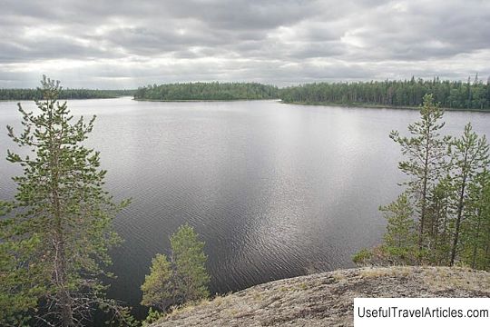
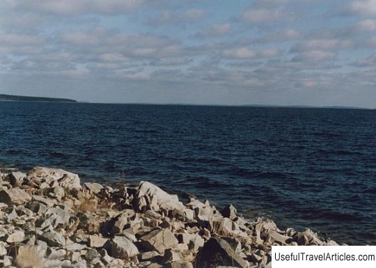
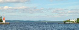
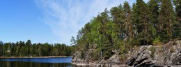
Lake Keret description and photos - Russia - Karelia: Louhsky district. Detailed information about the attraction. Description, photos and a map showing the nearest significant objects. Photo and descriptionLake Keret is considered one of the most picturesque bodies of water in the Republic of Karelia. The coastline of the lake is cut by a huge number of capes, coves, islands and bays, which makes Keret an extraordinary system of stretches, which are connected by narrow channels. Each reach lake has its own name, for example, Serebryanoe, Severnoe, Plotichnoe, Kukkure Lake and some others. The area of the entire water surface of Keret Lake is 245 sq. Km, and the total area with the lands of the islands is Of 298 sq. Km The maximum length of the lake is 44 km and its width is 14 km. The lake has more than 140 islands, the total area of which is 53 sq. Km. The mainland coastline exceeds 380 km; height above sea level about 90.6 m. The lakeside area has a weakly expressed hilly plain, which is covered with forests and swamps. Coastal lakes are notable for their lowness, as well as swampiness, only some places have elevated shores. Keret Lake contains a considerable number of bays protruding into the lake from the peninsula and a considerable number of islands, which are scattered throughout all parts of the reservoir. The island of Vitchany, located in the south of the lake area, is interesting in its size and rugged shape. The catchment area of the lake is small. More than a dozen small rivers and streams flow into the lake, which originate from flattering lamb and swamps. The source is located in the western part of the Plotny Lake. Keret Lake is considered to be shallow with a particularly developed coastal zone, which occupies more than half of the territorial area of the reservoir. The maximum depth of 26 meters was found in the western area of Plotnichy Lake; the average depth of the lake is 4.5 m. Some parts of the lake have depressions that are 15 meters deep. In addition, there is another kind of elevation at the bottom. Most of the bottom is covered with olive, brown or gray silt. In places where there is a shallow zone, there are sandy, rocky and rocky-sandy soils. In some areas of the Keret Lake there are lake ponds. The lake is replete with developed higher aquatic vegetation, because the coastal zone of the reservoir is especially wide: there are bays that are almost completely covered with aquatic vegetation; it happens that thickets grow in a continuous strip, stretching from 1 to 2 km. Vegetation is dominated by reed, reed, horsetail, sedge, water lily and other species. Higher vegetation also grows in the lake, but in small quantities. As for the thermal regime of Keret Lake, we can say that it is significantly different from the large lakes of the Karelian Republic, which mainly have cold waters. In summer, the surface water temperature reaches 21-22 ° C, which refers to the month of July. In some parts of the water column, relatively high temperatures from the bottom to the surface of the water are observed, which brings the state of water closer to homothermy. Towards the end of July, at a depth of 10 meters, temperatures at the bottom reach 16-17 ° C, at a depth of 21 m in some isolated pits, a lower temperature is observed (11.5 ° C). The freezing of the lake occurs at the end of October or at the beginning of November, and the ice begins to melt only from the second half of May. The oxygen saturation of the Keret Lake waters is very high, usually in the range of 90-100% of the required saturation. In winter, there is a possibility of a significant lack of oxygen. The lake waters have a slightly acidic reaction with a pH value of 6.6-6.7. The content of hydrocarbonates in lake water is 8.54-13.60 mg / l - this is low-mineralized water. Vingel-lake, located in the southern part of Keret-lake, is connected with the reservoir. The connection of the lakes takes place through the Niva River, which is a fishing ground for a large number of fishermen. The river has many swampy areas, behind which the forest stretches. Sandy beaches and granite outcrops are found in the southeastern part of the coast. Of considerable interest is the Silver Lake, which literally abounds in open and wide reaches;       We also recommend reading Assumption Cathedral of the Kirillo-Belozersky Monastery description and photos - Russia - North-West: Vologda Oblast Topic: Lake Keret description and photos - Russia - Karelia: Louhsky district. |