Rano Kau volcano description and photos - Chile: Easter Island
Rating: 8,6/10 (402 votes) 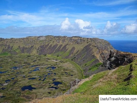
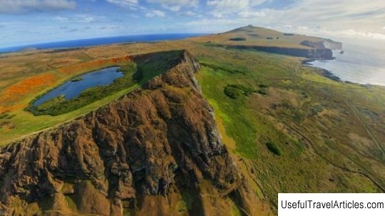
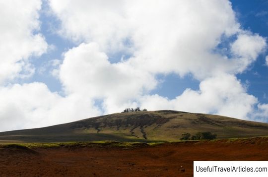
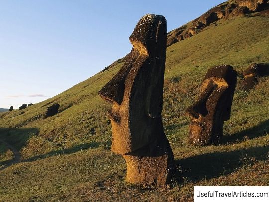
Rano Kau volcano description and photos - Chile: Easter Island. Detailed information about the attraction. Description, photographs and a map showing the nearest significant objects. The title in English is Rano Kau. Photo and descriptionRano Kau volcano is located in the southwestern part of Easter Island. Its spectacular eruption about two and a half million years ago led to the birth of the island. Its crater, more than a kilometer in diameter, forms a spectacular natural amphitheater about 200 meters deep and contains a large freshwater lake that was once one of the main sources of fresh water for the inhabitants of Rapa Nui. At the top of the crater, there is an edge fracture or 'bite' called Kari-Kari. The surface of the lake is covered with cattail (a type of plant that can also be found on the floating islands of Lake Titicaca in Peru). The more or less stable level of the lake, about 10 feet deep, allowed scientists to conduct sedimentary analysis to determine the disappearance of flora. as well as when human deforestation began on Easter Island. The ideal shape of Rano Kau protects plants from the strong winds in the area and prevents grazing animals from entering. Thanks to this, the toromiro tree was saved from extinction in 1950. In the narrowest part of the western edge of the volcano, the inhabitants of Rapa Nui built the Orongo ceremonial village, where people gathered for important rituals. From the top of Rano Kau crater you can see a fantastic view of the coast. A little to the right of the top of the crater, you can see that there are several petroglyphs on the rock. There are two ways to get to Rano Kau - by car or walking. If by car, the path will start from Hanga Roa, you will drive along the path to the airport, and then turn right. Pass the gas station and simply continue your way up to the crater of the Rano Kau volcano. You can walk along the path from the Sonaf Gardens, past the entrance to the Ana-Kai-Tangata cave. The entire route is more or less visible and you are unlikely to get lost. The climb to the top of the crater takes about an hour, and you can see Hanga Roa and the coast in all its glory. The most convenient time to visit the Rano Kau crater is a little after noon, when the sun sparkles in the waters of the lagoon.      We also recommend reading Church of the Assumption of the Blessed Virgin Mary in Butyrskaya Sloboda description and photos - Russia - North-West: Pskov Topic: Rano Kau volcano description and photos - Chile: Easter Island. |