Seaside regional park (Pajurio regioninis parkas) description and photos - Lithuania: Palanga
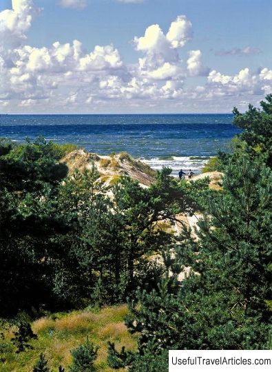
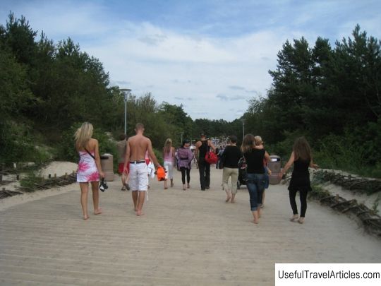
Seaside regional park (Pajurio regioninis parkas) description and photos - Lithuania: Palanga. Detailed information about the attraction. Description, photographs and a map showing the nearest significant objects. The name in English is Pajurio regioninis parkas. Photo and descriptionSeaside Regional Park is a territory of Lithuania located between old Palanga and Klaipeda and is under protection. You can go to the park along bike paths under the shade of trees, and you can also go horseback riding. The total area of the park is 5033 hectares. More than half of the territorial area of the park is located on the sea and is approximately 30 sq. km. The length of the Lithuanian coastal line is not that long, but despite this, there are many places where you can have a great rest, and which are so popular among foreign tourists. In 1992, the Primorsky or Karkliai Regional Park was established and began its work. The park was created in order to preserve such a picturesque landscape of the seaside, biological wealth and diversity of the sea, cultural and natural values, as well as creating the most favorable conditions for the successful development of tourism in this area. The Seaside Park is divided into several zones. Not far from the residential area, there is the Placiai nature reserve, landscape reserves in Shaipiai and Nemirset, the Dutchman's cap reserve, the Karkla botanical reserve, the Thalassological and ethnocultural reserves located in Karkla, the botanical and zoological reserve in Kalota, as well as areas intended for restoration works and agricultural areas. Even 10-15 thousand years ago, the Lithuanian seaside was covered with a glacier. During its descent, a moraine appeared on the seashore. Today the highest point of the moraine is called the "Dutchman's Hat". This peak is a hill that rises above the sea to a height of 24 meters. Under the influence of sea waves, a 22-meter cliff was formed at the foot of the hill. The territory of the park has two lakes of glacial origin, they are called Plotsis and Kalote. The constituent parts of the shores of the ancient sea, which is called the Litorina Sea, have also been preserved. It was located in this place more than 8 thousand years ago. Nearby with a place called Nemirseta, you can more carefully and carefully examine the fragments of the coast. As for the cultural heritage, the ancient settlements, excluding the southern part of Karkle, for the most part, are practically not preserved. Only a few estates in Nemirset and Shaipiai have survived to this day. In some ways, the villages were better preserved: Darguziai, Bruzdelinas, Hrabiai, Kalote, as well as the southern part of Karlininkai. In the old town of Kalote, a tavern, several manors and an old school have survived to this day. In the south-western part of Kalote, namely in a small forest, there is an ancient cemetery, where graves with stone wreaths were discovered, which were especially common in the first millennium BC. In the southern part of the town of Karkle, there are remains of old manors, as well as a cemetery, which are located on a natural hill in the northern part of the Dutchman's Cap. The cemetery still contains authentic tombstones, which are made of wood "krikstasy" (later they were replaced with iron ones, and later with cement ones). By the first half of the 20th century, this cemetery acquired its name - the cemetery "Liepu" or "Linden" cemetery. Two wooden estates built in the form of a rectangle have survived in Shaipiai. The buildings are one-story and were built at the very beginning of the 20th century. There are gardens and trees near the manors. The restored kurhauz is located in Nemirset. Kurhaus is located on the site of a tavern, which was mentioned in the 15th century. A rescue station is now located on the seashore, built in the early years of the 20th century. The restored Kurhaus is located in Nemirset. Kurhaus is located on the site of a tavern, which was mentioned in the 15th century. A rescue station is now located on the seashore, built in the early years of the 20th century. The restored Kurhaus is located in Nemirset. Kurhaus is located on the site of a tavern, which was mentioned in the 15th century. A rescue station is now located on the seashore, built in the early years of the 20th century.      We also recommend reading The Rose Garden description and photos - Thailand: Bangkok Topic: Seaside regional park (Pajurio regioninis parkas) description and photos - Lithuania: Palanga. |