Big Gate Canyon description and photos - Russia - North-West: Nenets Autonomous Okrug
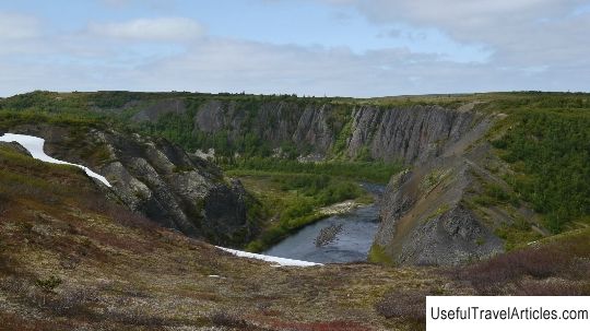
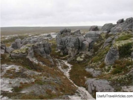
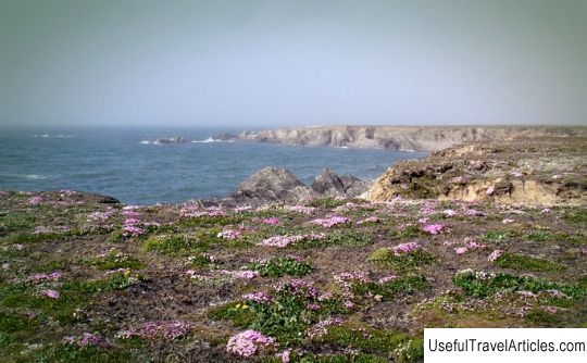
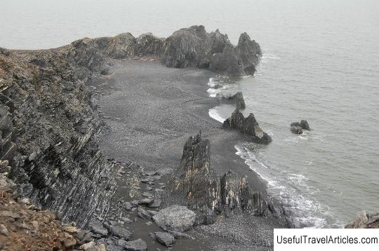
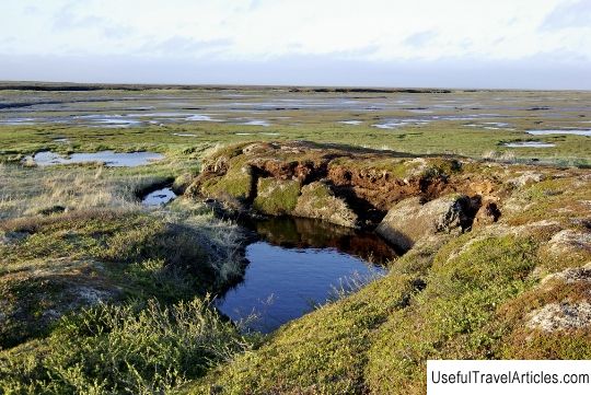
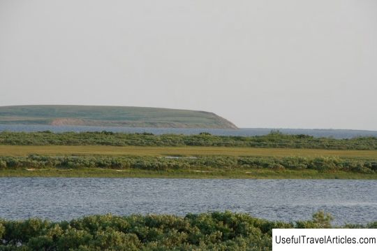
Big Gate Canyon description and photos - Russia - Northwest: Nenets Autonomous Okrug. Detailed information about the attraction. Description, photos and a map showing the nearest significant objects. Photo and descriptionThe natural monument "Big Gate Canyon" is located in the Nenets Autonomous Okrug, its area is 212 hectares. It was created to preserve complexes of nature within the canyon, outcrops of minerals, outcrops of rocks, natural landscapes of the Belaya River, paleontological, geological, ichthyological, botanical objects of the Timan tundra. The landscape of this natural monument is represented by picturesque coastal cliffs of basalts period of the Upper Devonian, with a height of 80-90 m. In the basalts of the canyon, inclusions of agates and other minerals are observed. This territory is of particular importance in the paleontological plan. 300-400 million years ago the coast of the Devonian Sea was located here. At present, its sediments are visible in the cliffs of the river banks. In the sandy and shale cliffs of the Upper Devonian, remains of shells, teeth of shell fish, various corals, trilobites, imprints and remains of Upper Devonian plants were discovered. The Belaya River flows through the territory of the Big Gate canyon with many rocky rifts, its the width within the canyon is 25-30 m. It is a spawning ground for salmon and a habitat for char and grayling. Rare mountain-tundra plants such as bluegrass, small-leaved resin, blackish skerda, blue phyllodoce, arctic gentian are included in the Red Book of the Nenets Autonomous Okrug. The western boundary of the natural monument is the beginning of a steep canyon, where the Belaya channel narrows; east - the end of the canyon, where the river valley expands in front of the bay, which is formed in the channel of the Belaya on the right bank; southern and northern borders - steep and high banks on both sides of the river. On the territory of the Big Gate canyon, any economic and other activities that lead to a violation of the preservation of the natural monument are prohibited, including: deforestation, not including sanitary and recreational activities; the production of geological and agricultural works, including the use of mineral fertilizers, plant protection chemicals, pesticides, growth stimulants, including grazing, plowing land; mining; collection of plants included in the Red Book; collection of ornamental stones and collection materials; parking lot for ground vehicles and others. On the territory of the canyon, it is allowed, in agreement with the Agency for Natural Resources and Ecology: to carry out environmental protection measures aimed at preserving river landscapes, paleontological, geological, ichthyological, botanical objects, and other activities that do not contradict the objectives of the natural monument and the regime of its protection; to place the economic and production facilities of the natural monument. Also on the territory of a natural monument it is allowed to: conduct scientific research, including environmental monitoring; organize environmental educational events (educational and educational excursions, equip ecological study trails, shoot videos). Sports and recreational fishing in river and lake waters on the territory of the monument is possible subject to the legislation on fishing. to carry out nature conservation measures aimed at preserving river landscapes, paleontological, geological, ichthyological, botanical objects, and other measures that do not contradict the objectives of a natural monument and the regime of its protection; to place the economic and production facilities of the natural monument. Also on the territory of a natural monument it is allowed to: conduct scientific research, including environmental monitoring; organize environmental educational events (educational and educational excursions, equip ecological study trails, shoot videos). Sports and recreational fishing in river and lake waters on the territory of the monument is possible subject to the legislation on fishing. to carry out nature conservation measures aimed at preserving river landscapes, paleontological, geological, ichthyological, botanical objects, and other measures that do not contradict the objectives of a natural monument and the regime of its protection; to locate economic and industrial objects of the natural monument. Also on the territory of a natural monument it is allowed to: conduct scientific research, including environmental monitoring; organize environmental education activities (educational and educational excursions, equip environmental study trails, shoot videos). Sports and recreational fishing in river and lake waters on the territory of the monument is possible subject to the legislation on fishing. ichthyological, botanical objects, other activities that do not contradict the objectives of the natural monument and the regime of its protection to place the economic and production facilities of the natural monument. Also on the territory of a natural monument it is allowed to: conduct scientific research, including environmental monitoring; organize environmental education activities (educational and educational excursions, equip environmental study trails, shoot videos). Sports and recreational fishing in river and lake waters on the territory of the monument is possible subject to the legislation on fishing. ichthyological, botanical sites, and other activities that do not contradict the objectives of the natural monument and the regime of its protection; to locate economic and industrial objects of the natural monument. Also on the territory of a natural monument it is allowed to: conduct scientific research, including environmental monitoring; organize environmental education activities (educational and educational excursions, equip environmental study trails, shoot videos). Sports and recreational fishing in river and lake waters on the territory of the monument is possible subject to the legislation on fishing. Also on the territory of a natural monument it is allowed to: conduct scientific research, including environmental monitoring; organize environmental educational events (educational and educational excursions, equip ecological study trails, shoot videos). Sports and recreational fishing in river and lake waters on the territory of the monument is possible subject to the legislation on fishing. Also on the territory of a natural monument it is allowed to: conduct scientific research, including environmental monitoring; organize environmental education activities (educational and educational excursions, equip environmental study trails, shoot videos). Sports and recreational fishing in river and lake waters on the territory of the monument is possible subject to the legislation on fishing.        We also recommend reading Oginski manor (Oginskiu rumai Plungeje) description and photos - Lithuania: Kretinga Topic: Big Gate Canyon description and photos - Russia - North-West: Nenets Autonomous Okrug. |