Nazca Geoglyphs (Lineas de Nazca) description and photos - Peru: Nazca
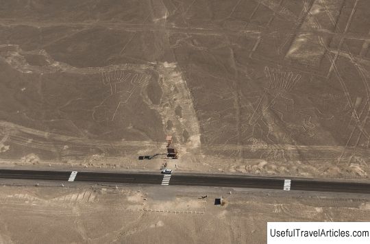
Nazca Geoglyphs (Lineas de Nazca) description and photos - Peru: Nazca. Detailed information about the attraction. Description, photographs and a map showing the nearest significant objects. The title in English is Lineas de Nazca. Photo and descriptionThe Nazca geoglyphs, found in the Nazca desert, between the cities of Nazca and Palpa, appeared during the period of prosperity of the Nazca culture from 700 BC. before 200 A.D. There are several hundred of them, ranging from simple lines to complex zoomorphic and geometric shapes on the surface of the earth. 450 km south of Lima, near the Pacific Ocean, there are the pampas (in Quechua, pamp means `` plain ''; ) Ingenio, Nazca and Sokos. Between Nazca and Palpa de Sokos, lines ranging from 40 to 210 cm wide can be seen drawn on the black and red soil. Not far from these lines is a semicircle of hills, from where a gigantic natural amphitheater opens up. Some of the lines are up to 275 meters long. Technically, the Nazca lines are very clear and even, with practically no deviations. Maybe, ropes, stakes and about 800 animals were used in their creation. The exceptional climate of the region, where there is practically no rain, has been a reward for the ingenious creators of these drawings, preserving this amazing work to this day. Contrary to popular belief that the Nazca lines can only be seen from the air, travelers can easily view them from the surrounding hills and specially designed observation towers. The first record of them was made by the Peruvian archaeologist Toribio Mejia Kesspe in 1927. A large systematic laboratory study of these drawings was carried out by the team of the Swiss Foundation for Archaeological Research Abroad, led by archaeologist Marcus Reindel and Johnny Isla Cuadrado in 1996, who carried out numerous excavations and managed to trace the history of culture. who created these drawings. In fact, these lines are simple furrows made in the ground, the soil surface of which consists of a layer of dark pebbles with a reddish tint caused by oxidation. Archaeologists have concluded that the lines were drawn between 200 BC. and 600 A.D. On the territory of the Nazca Desert, stones were also found in small mounds that could be used to create these giant drawings. The technique for creating the drawing was fully restored with evidence collected by archaeological expeditions, and was clearly demonstrated. Archaeological excavations have revealed in some Nazca geoglyphs an image of religious offerings of agricultural products and animals, especially marine ones. Geoglyph lines form the ritual landscape, the purpose of which is to facilitate the induction of rainwater. Stakes and ropes were also found. Recently, the condition of the lines is deteriorating due to the influx of people inhabiting nearby lands, as well as serious damage to some geoglyphs as a result of the construction of the Pan American Highway. In 1994, the UNESCO Committee inscribed the Nazca geoglyphs and the Pampa de Jumana plain geoglyphs on the World Heritage List.      We also recommend reading Gate of Hisar Kapia description and photos - Bulgaria: Plovdiv Topic: Nazca Geoglyphs (Lineas de Nazca) description and photos - Peru: Nazca. |